
Hurricane, tropical storm and storm surge watches have been issued for parts of the U.S. Gulf Coast as Tropical Storm Isaias was «quickly intensifying» and was expected to approach that area Friday after becoming a hurricane, according to the National Hurricane Center.
Currently swirling in the Gulf, Isaias would be the Atlantic Basin’s first hurricane of the season and is its ninth named storm. El Niño continues to bring a more active season in the Pacific. The storm formed with less than two months remaining in the 2026 hurricane season, which ends Nov. 30.
Maps show possible path
Tropical Storm Isaias, which grew from Tropical Depression Nine on Wednesday and is pronounced «ees-ah-EE-ahs,» is expected to pass to the north of Mexico’s Yucatan Peninsula on Thursday and make landfall along the northern Gulf Coast of the U.S. late Friday or early Saturday, the hurricane center said.
A hurricane watch was issued Wednesday for the northern Gulf Coast, from Bay St. Louis, Mississippi, to Indian Pass, Florida, and a tropical storm watch was issued from Bay St. Louis to Louisiana’s Jefferson/Plaquemines Parish line and from Indian Pass to Florida’s Aucilla River. A storm surge watch was also issued from the mouth of the Mississippi River to Yankeetown, Florida, according to the hurricane center.
Tropical storm-force winds were extending outward up to 60 miles from the storm’s center early Wednesday evening. At the time, its maximum sustained winds were 65 mph, according to the hurricane center, and it was forecast to become a hurricane by Thursday morning.
A storm’s maximum wind speed must rise to at least 74 mph to be considered a hurricane.
Nikki Nolan/CBS News 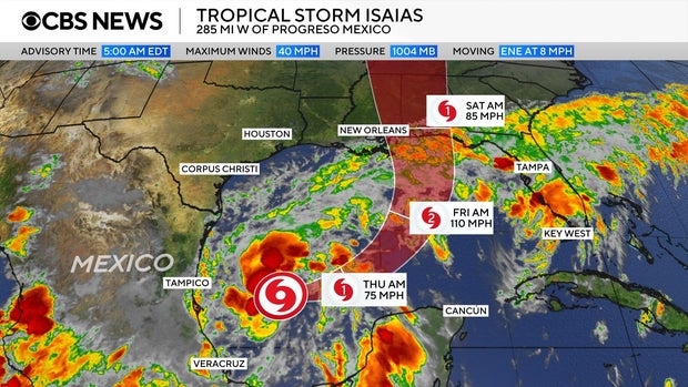
Isaias is forecast to bring moderate to heavy rainfall to the Gulf Coast and into the rest of the Southeast this weekend into early next week. The hurricane center forecasts 3 to 6 inches of rain and as much as 10 inches in some places on the central Gulf Coast from southeastern Louisiana to the Florida Panhandle.
Some longer-range forecast models also see this moisture eventually reaching the Ohio Valley and Northeast by midweek next week.
CBS News/Nikki Nolan 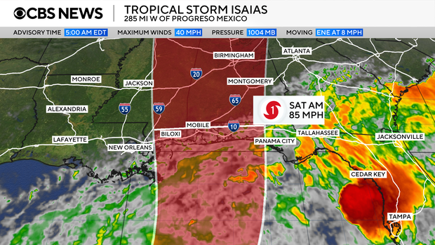
The hurricane center on Thursday warned of «an increasing risk of dangerous wind and storm surge impacts» along parts of the northern Gulf Coast and urged people living in Louisiana, Alabama, Mississippi and northern Florida to «closely monitor the latest forecast updates and ensure they have their hurricane plan in place.» At high tide, the approximately 300-mile stretch between Ocean Springs, Mississippi, and Indian Pass, Florida, could see a storm surge of up to 7 feet, forecasters said, potentially causing major flooding.
In addition to rain, the hurricane center said Isaias could potentially bring urban flooding and isolated river flooding to places in its path.
Florida Gov. Ron DeSantis on Tuesday signed an executive order declaring a state of emergency for 25 Florida counties ahead of the storm’s arrival. DeSantis said in a statement that the order «ensures communities have the time and resources necessary to prepare for potential severe weather impacts to the Panhandle and Big Bend region of Florida.»
On Wednesday, Alabama Gov. Kay Ivey issued a similar state of emergency for 40 counties, saying in a statement this will allow Alabama officials «to take any needed steps ahead of landfall.»
Beware the «I»-named storm
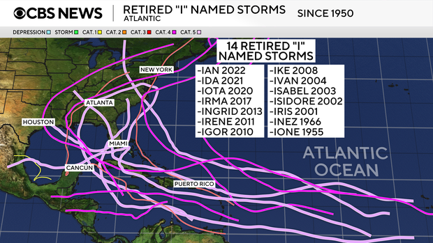
While tropical storm and hurricane formation and frequency vary throughout the season, the «I»-named systems tend to be the most retired names within the Atlantic basin.
The most commonly known retired «I»-named storms are Ian (2022), Ida (2021), Irma (2017) and Irene (2011).
When Ike was retired in 2008, Isaias replaced the «I» name on the Atlantic tropical cyclones list, which rotates every six years.
CBS News